Table of Contents
One. Spatial Data Introduction
1. Global Country Information Table
3. National Airport Search Implementation
II. Spring Boot Backend Implementation
2. Controller Layer Implementation
3. Implementation of WebGIS Visualization
1. Leaflet Interface Implementation
2. Achievements in Visualization of Countries and Airports
3. Global Airport Quantity Ranking Chart
Foreword
The Spring Festival is approaching, and after a year of hard work, many people are already preparing to pack their luggage and set off on the journey home. Life is challenging; we hereby extend our best wishes for a happy Spring Festival and a joyful family reunion to everyone. With the advancement of times and changes in transportation methods, there are now various ways for people to travel. In the past, traditional trains were the primary mode of transportation before the era of high-speed rail. During the peak of Chunyun (Spring Festival travel rush), every railway station’s ticket office would be crowded with people. That small train ticket was a symbol of the longing for home. The green-skin trains were the main mode of transportation for many migrant workers heading home, besides trains and private cars; some from Yunnan and Guizhou regions choose to ride motorcycles home along with their wives to save on travel costs. Back in the day, air travel was an option that most people would hardly consider, not only because of its high cost but also due to the limited luggage allowance. Nowadays, airports are closely integrated with railways and bus stations; some have even formed combined complexes, such as Shanghai Hongqiao Airport and Hongqiao High-Speed Railway Station located together. Whether taking the high-speed rail or a flight, passengers can easily transfer at this complex. In most traditional transportation systems of other cities, people choose airport buses or taxis to get to the airport, while many cities now have subways; some even have maglev lines, such as the medium- and low-speed maglev line running between Changsha South High-Speed Railway Station and Changsha Huanghua International Airport, with additional Metro Line 6 directly connecting to the airport terminal. This reflects how closely integrated China’s airport transportation systems are. The following figure is a schematic diagram of the spatial distribution of Chinese airports:
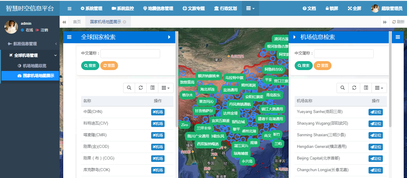
In terms of connecting China with foreign countries, aviation stands out as a rapid and convenient mode of transportation, offering a more humane approach compared to shipping. It naturally holds an advantage in facilitating the movement of people. Unlike the slow voyages of cargo ships or merchant vessels across vast oceans, air travel significantly accelerates the journey between nations. Consequently, whether studying domestic airport layouts, flight patterns, traffic optimization, or the degree of connection between China and other countries, especially during times like the pandemic when timely control measures are needed for infected countries to curb the spread of the virus—these all highlight the importance of researching the scale and spatial layout of airports globally. Although previous blog posts have covered topics such as flight patterns and airport data handling, with a focus on data collection, storage, retrieval, and spatial visualization (as seen in articles like “Practical Implementation of Global Airport Data Ingestion Using SpringBoot and PostGIS” and “Practical Spatial Distribution Visualization of Global Airports Using SpringBoot and Leaflet“), there is a lack of analysis from the perspective of individual countries.
Some readers have reached out, expressing a desire to combine country information with airport data for comprehensive visualization and explanation. This article focuses on how to use SpringBoot and PostGIS to achieve web-based GIS visualization of countries and their associated airports. Through this guide, you will not only learn how to develop web GIS using SpringBoot and PostGIS but also gain a global perspective on aviation patterns. Moving forward, integrating flight website data could enable the construction of a global view of air connectivity, providing precise support for assessing international and regional connectivity.
1. Basic Introduction of Spatial Data
This section focuses on the two tables involved in spatial data: the first table contains global country information, and the second table contains global airport information. The country information table and airport information table have a one-to-many relationship. Although these two tables were mentioned earlier in previous blog posts, this section will still take up some space to explain them for the benefit of new readers who are encountering this content for the first time. Readers who have previously read the earlier blog posts can skip ahead to other sections.
1、Global Country Information Table
The global country information table contains eight fields: English full name, English abbreviation, simplified name, Chinese full name, Chinese abbreviation, continent affiliation, continent details, and spatial Geom.
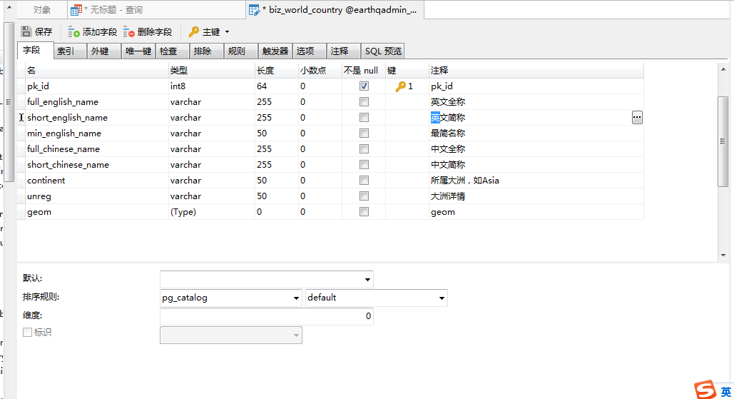
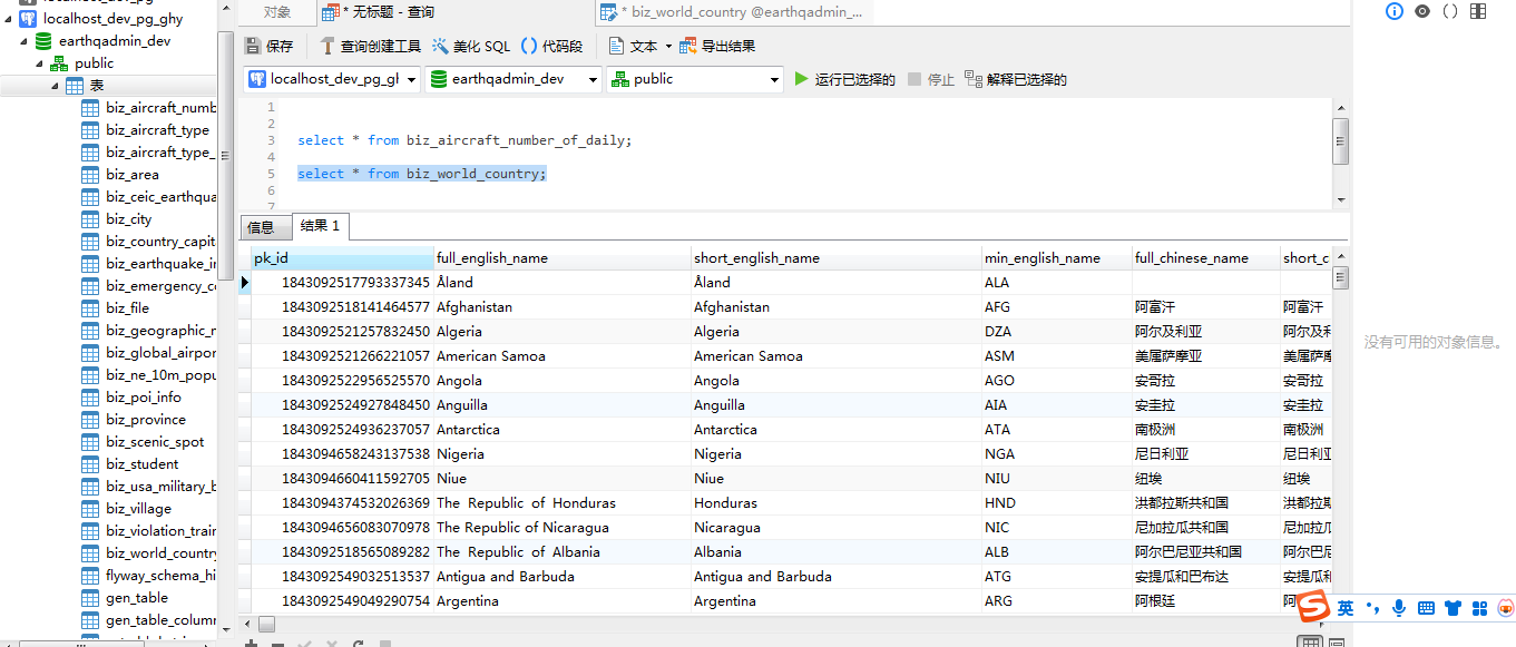
Use the following SQL statement to query the data:
|
1 |
select * from biz_world_country; |
The client will return the following results:
2、Airport Information Table
The airport information table contains the following fields: IATA three-letter code, Chinese name, English name, longitude-wgs84, latitude-wgs84, city name, country English abbreviation, country/region in Chinese, and spatial Geom field information. The structure of this table is as follows:
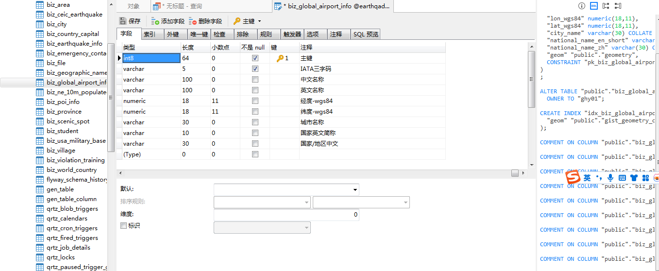
You can also use SQL statements to query airport information as follows:
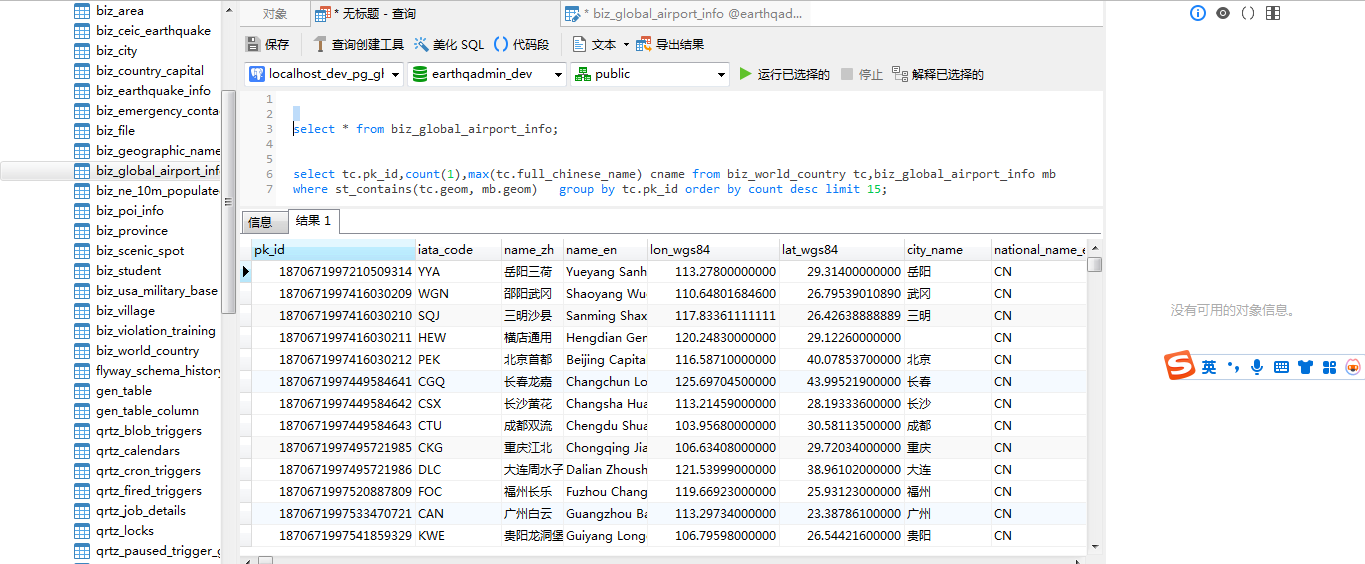
Regarding country information and airport information, you can find them on the internet. It is important to note that for vector boundary data involving special regions, please use standard maps. This data should not be used for commercial purposes.
3、Airport Retrieval Based on Country
To perform containment queries in spatial data, the st_contains spatial function is generally used. Although the airport information table previously reserved a field for country information, this field is only used for display purposes. For spatial containment queries, the_geom fields of two spatial tables are used as association fields. The SQL query statement is as follows:
|
1 2 |
select mb.* from biz_world_country tc,biz_global_airport_info mb where st_contains(tc.geom, mb.geom) and tc.pk_id = 1843094044926840833; |
After executing the above statement, you can see the following execution results in the database client:
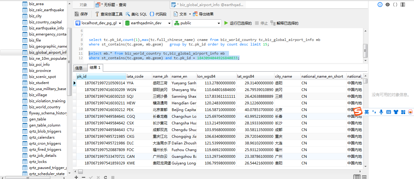
It can be seen that there are 317 entries of airport data in the database (data source: online sharing). If there are any inaccuracies, please feel free to contact me privately. Regarding the number of airports in other countries, this will not be discussed for now. Eventually, we will conduct a ranking of global aviation airport numbers. This concludes the introduction of spatial data for this section. I hope it helps in understanding.
2、Backend Implementation with Spring Boot
This section will provide a detailed explanation on how to implement backend functionality using Spring Boot, covering two main aspects: the implementation of the model layer and the implementation of the control layer.
1、Model Layer Implementation
Corresponding to the spatial information table introduced in the previous section, the model layer also includes two aspects: country entity classes and database operation Mapper classes (for both countries and airports). The main content is illustrated by the following mind map:
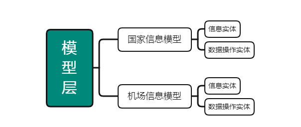
In the country information model and airport information model, information entities refer to entity classes that have a one-to-one correspondence with the respective spatial data tables. Data operation entities primarily involve database operations based on these entity classes, such as data addition, modification, and query retrieval. For country information retrieval, it is necessary to provide a search function by Chinese short name of the country and a method to return its corresponding GeoJSON data based on country ID. The following table lists the details:
| No. | Method | Description |
| 1 | TableDataInfo list(WorldCountries wCountry) | Query paginated list of countries based on conditions |
| 2 | AjaxResult getGeojson(@PathVariable(“id”) Long id) | Query GeoJSON data for country by ID |
Similarly, as with the national Mapper operation entity, corresponding operational methods are also required in the airport Mapper entity.
| Number | Method | Description |
| 1 | GlobalAirportInfo findGeoJsonById(@Param(“id”)Long id) | Query airport GeoJSON by ID |
| 2 | List<GlobalAirportInfo> findAirportListByCountryId(@Param(“countryId”) Long countryId,@Param(“name”) String name) | Query airport list based on country ID and name |
Now, let’s look at the specific Java implementation code, taking GlobalAirportInfoMapper.java as an example:
|
1 2 3 4 5 6 7 8 9 10 11 12 13 14 15 16 17 18 19 20 21 |
package com.yelang.project.transportation.flight.mapper; import java.util.List; import org.apache.ibatis.annotations.Param; import org.apache.ibatis.annotations.Select; import com.baomidou.mybatisplus.core.mapper.BaseMapper; import com.yelang.project.transportation.flight.domain.GlobalAirportInfo; public interface GlobalAirportInfoMapper extends BaseMapper<GlobalAirportInfo>{ static final String FIND_GEOJSON_SQL=“<script>“ + “select st_asgeojson(geom) as geomJson from biz_global_airport_info “ + “where pk_id = #{id} “ + “</script>“; @Select(FIND_GEOJSON_SQL) GlobalAirportInfo findGeoJsonById(@Param(“id”)Long id); static final String FIND_AIRPORTLIST_BY_COUNTRYID_SQL = “<script>“ + “select mb.* from biz_world_country tc,biz_global_airport_info mb “ + “where st_contains(tc.geom, mb.geom) and tc.pk_id = #{countryId} “ + “<if test=‘null != name’> and name_zh like concat(‘%’, #{name}, ‘%’)</if>” + “</script>“; @Select(FIND_AIRPORTLIST_BY_COUNTRYID_SQL) List<GlobalAirportInfo> findAirportListByCountryId(@Param(“countryId”) Long countryId,@Param(“name”) String name); } |
2. Control Layer Implementation
The control layer is the core processing class providing web services to the outside world, where all methods interacting with external systems are defined. For displaying lists of countries and their airports on our interface, we need to show two separate lists, handle two query conditions, display different GeoJSON data, and perform associated queries. For instance, when switching countries, the airport information list should update in real-time. Regarding the API for managing country information, it’s relatively straightforward, and here we’ll provide an example of the airport information interface API development.
|
1 2 3 4 5 6 7 8 9 10 11 12 13 14 15 16 17 18 19 20 21 22 23 24 |
/** * – Retrieve List of Airport Information * @param * @return */ @PostMapping(“/allairport”) @ResponseBody public AjaxResult allairport(Long countryId){ List<GlobalAirportInfo> list = airportInfoService.findAirportListByCountryId(countryId,null); AjaxResult ar = AjaxResult.success(); ar.put(“data”, list); return ar; } /** * Page List of Country Airport Information */ @RequiresPermissions(“trans:flight:airportinfo:countrymap:pagelist”) @PostMapping(“/pagelist/bycountry”) @ResponseBody public TableDataInfo databycountry(Long countryId,String airportName){ startPage(); List<GlobalAirportInfo> list = airportInfoService.findAirportListByCountryId(countryId,airportName); return getDataTable(list); } |
In the aforementioned code, for the airport information list and pagination list, we use two interfaces to implement them for simplicity. In fact, they can be merged into a single implementation or have their data display converted into WMS or other vector tile base maps. This approach significantly reduces the redundancy of system interfaces and improves access performance in large-scale data scenarios. That concludes the SpringBoot backend implementation.
Three、WebGIS Visualization Implementation
The web interface serves as the application layer and is our system’s portal. All system functions are provided to users through the interface. This section focuses on how to implement the display of national and airport information in WebGIS. In WebGIS, we need to achieve the following functionalities: using a sidebar to list national and airport information; supporting information queries for both lists, including searching by Chinese names of countries and airports; and enabling interactivity between the two lists. When a country is selected, the airport list automatically updates accordingly.
1、Leaflet Page Implementation
To facilitate search and display on the interface, we use sidebars to separately display national information and airport information. The left sidebar shows country information while the right sidebar displays airport information. When clicking on an airport button in the left country list, the right airport list automatically refreshes and retrieves data from the backend to update the airport information. For details on how to bind and implement dual-table query parameters in RuoYi, please refer to previous blog posts. To maximize the display of the map interface, we use a click event on airport information to collapse the country information table. The key code is as follows:
|
1 2 3 4 5 6 7 8 9 10 11 |
function initSidebar(){//Initialize sidebar page sidebar = L.control.sidebar(‘sidebar’, {position: ‘left’}).addTo(mymap); //Default sidebar opens and displays one tab page sidebar.open(); $(“#xz_info”).addClass(“active”); $(“#home”).addClass(“active”); //Initialize administrative division table initWorldCountryTable(); rightSidebar = L.control.sidebar(‘sidebar-right’, {position: ‘right’}).addTo(mymap); initAirportTable(); } |
For displaying GeoJSON data and maps in Leaflet, we will not go into detail here. If specific code is needed, please feel free to reach out for communication.
2、World and Its Airports Visualization Results
After implementing the WebGIS display of data, let’s examine the distribution of airport information in different countries to verify if the system meets our expectations.
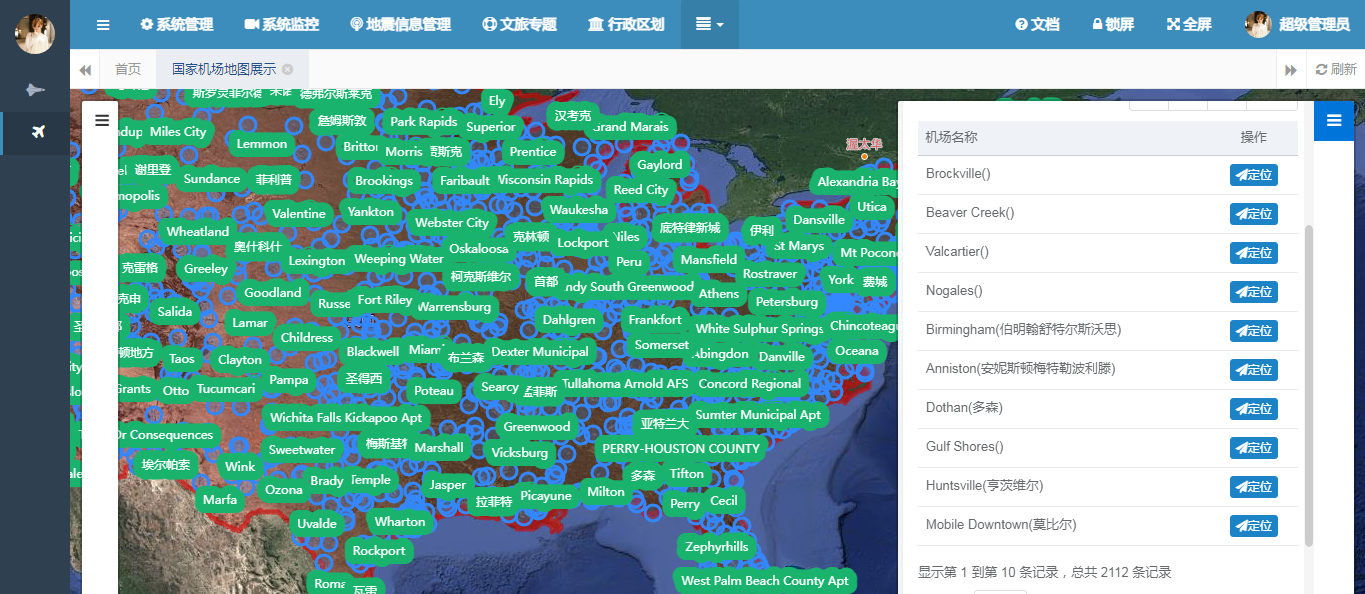
Overview of Airport Distribution in the United States
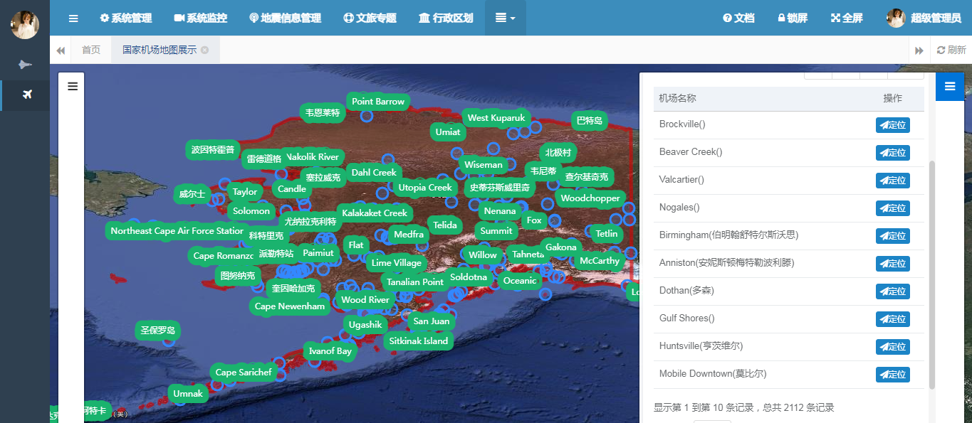
Diagram of Airport Distribution in Alaska, USA
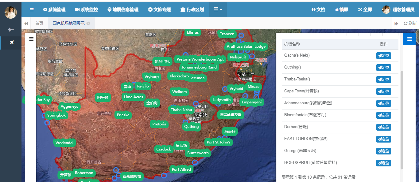
Diagram of Airport Distribution in South Africa
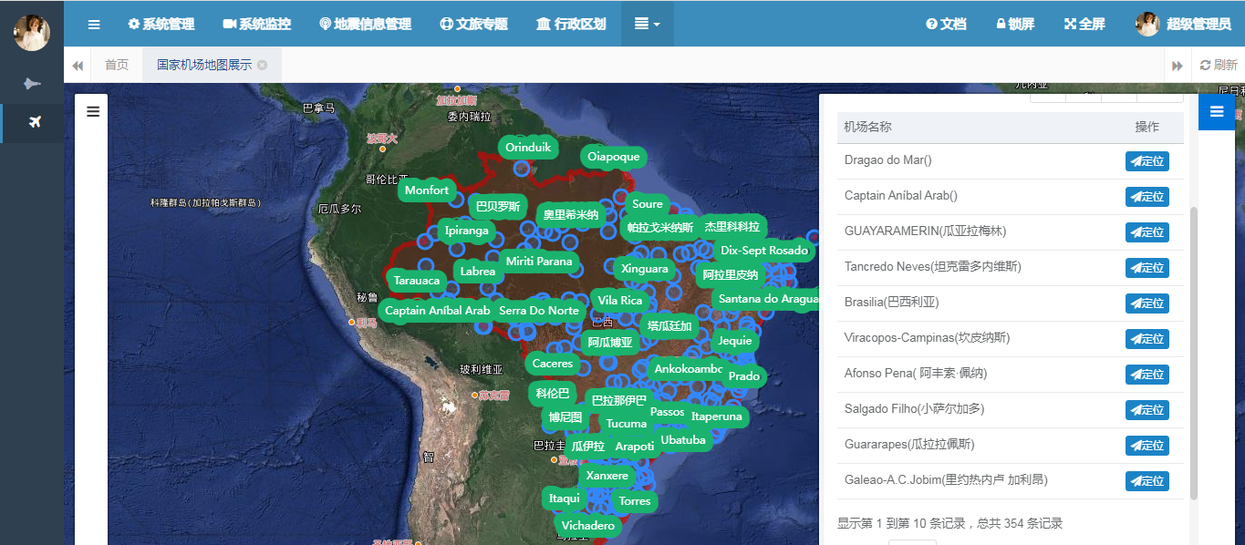
Brazil and its airport distribution diagram
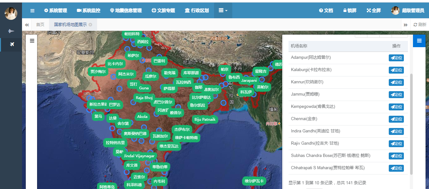
India and its airport distribution diagram
The above are some country airport distribution diagrams. Of course, these countries are just examples. If you’re interested in other countries not shown here, please message me and I will share their airport location maps with everyone.
3. Global Airport Quantity Ranking
Now let’s take a look at the global ranking of the number of airports in countries, where we display the top 10 rankings. The SQL query below demonstrates this implementation. The logic involves associating country and airport details through spatial containment functions and grouping by country to calculate the number of airports. Below is the SQL query:
|
1 2 3 |
select distinct count(1), max(tc.full_chinese_name) cname from biz_world_country tc, biz_global_airport_info mb where st_contains(tc.geom, mb.geom) group by tc.pk_id order by count desc limit 10; |
The client output is as follows:
|
1 2 3 |
[crayon–67efc79fc0018514050642 inline=“true” class=“language-sql”]count cname 2112 United States of America 597 Australia |
[/crayon]
484 Canada
354 Brazil
333 Papua New Guinea
317 People’s Republic of China
204 Russian Federation
195 The Republic of Indonesia
151 Columbia
141 India
Leave a Reply
You must be logged in to post a comment.